The AP Course builds on concepts introduced in the Piloting Course. This is a short review of the important concepts for AP.
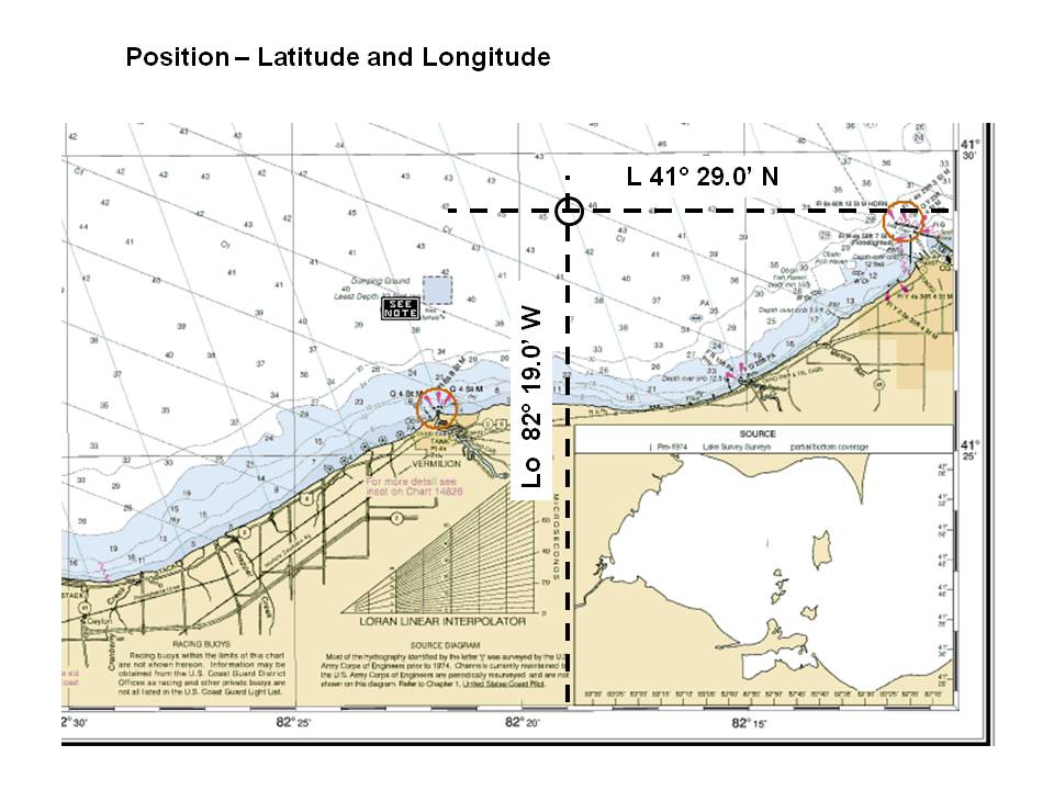
Position is defined by the intersection of Latitude and Longitude, as seen on a chart (see the first diagram below).
Course lines are drawn on the chart and labeled according to USPS convention. The bearing of the course line is measured with your Course Plotter.
If you would like a quick refresher on using the Course Plotter, you can download a short Powerpoint presentation here. (View in "Slide Show" mode and advance slide with mouse click.)
If you have not used the USPS Course Plotter before, I recommend you wait until we review it the first night of class, as it can be confusing the first time you try.
Akron Power Squadron - Advanced Piloting Class
Position is desribed as the intersection of latitude and longitude. The latitude scale is on the vertical edge of the chart. The longitude scale is on the top and bottom edge of the chart.
In USPS convention, we write Latitude as "L" and Longitude as "Lo". Latitude is designated as either North or South (N or S), and Longitude as East or West. USPS convention is degrees, minutes, and tenths of minutes. If longitude is less than 100 degrees, USPS drops the leading "0".
In this example, a boat located at the center of the circle is located at L 41° 29.0 N and Lo 82° 19.0 W. On your GPS, you could define a waypoint at this location by entering L 41° 29.0 N and Lo 82° 19.0 W.
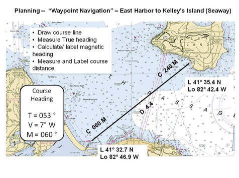
Planning can be considered "Waypoint Navigation", where you designate intermediate positions ("waypoints" ) along your route -- and navigate between each waypoint.
In the example to the left, your vessel is planning a trip from East Harbor (at the bottom left of the chart) to Seaway Marina on Kelley's Island (the upper right of the chart). In this example, the latitude and longitude of starting and ending waypoints are noted on the chart, for reference. This is not generally done in our course.
The course line is drawn between these points, and can be measured with your Course Plotter. All lines drawn on a chart are referenced to True North. The heading of this course is 053° True.
Charts represent the water and surrounding land. Charts are drawn with respect to "True North". Your boat's compass, however, aligns with "Magnetic North". The difference between True North and Magnetic North is "Magnetic Variation". Magnetic Variation is printed on a "Compass Rose" on every chart,
When planning a voyage, you draw the course line on the chart. You keep track of your progress on the chart.
This course will use standard plotting and labeling conventions. These conventions trace back to the history of navigation -- when the next watch comes onto the bridge of a vessel, they can immediately tell their course and position by looking at the chart.
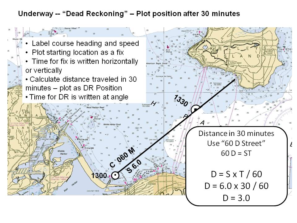
When Underway, you plot your progress with "Dead Reckoning", (short for "Deduced Reckoning", and referred to as "DR").
You generally start your trip at a known position, or "fix". A "fix" is plotted on the chart as a circle with a dot in the center. The time of the fix, in 24 hour clock, is written horizontally to the chart edges.
Your course line is labeled with the magnetic heading. Under the heading, the course is labeled with your speed in knots, in this case, "S 6.0".
Since we steer our boats with a magnetic compass, USPS convention is to label the course in Magnetic, even though it is drawn in True heading.
For this area of Lake Erie, variation is 7° West, which means Magnetic North is 7° west of True North. For West variation, the 7° is added to the true course to give us a course of 060° magnetic. (For East variation, you subtract Variation from True to give the compass course.)
USPS labels both ends of the course line with the magnetic heading, starting from that end. Going from East Harbor to Kelley's, this is labeled "C 060 M". Going the opposite direction, the course is labeled "C 240 M".
Course distance, in nautical miles, is labeled below the course line.
In the example above, after 30 minutes, you estimate or "deduce" your progress, based on your speed and the time you have traveled. We use the "60 D Street" mnemonic -- Distance in nautical miles, equals Speed in knots, times time in minutes, and divide by 60 (since we use time in minutes).
This is plotted as a DR (Dead Reconing) positon, plotted as a semi circle with a dot in the center. The time of the DR is written at an angle to the chart edges.