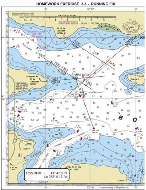
Refer to plotting standards, p 124
1. Start at 1300. L 41° 45.0’, Lo 71° 55.0’. This is a fix - should be labeled 1300 GPS, denoting a GPS fix (diagram is incorrect).
Course 230 T. Plot course line. Convert to magnetic. V = 15W. Label Course and Speed.
2. At 1330, you take compass bearing 318° on "Fl R 6 s horn."
Determine true bearing, plot as true, label as magnetic. Time goes above the bearing line, bearing goes below.
Calculate and plot DR position using 60 D = ST
3. At 1355, you take compass bearing 280° on "Chapman Pt - Fl 6 s."
Determine true bearing, plot as true, label as magnetic.
Calculate and plot 1355 DR position using 60 D = ST.
Advance 1330 bearing the distance between 1330 DR and 1355 DR (2.5 nm). Draw the advanced bearing at 303 T (318 M). This line will cross your course line 2.5 nm past the original intersection of course line and 1330 bearing.
Advanced bearing is labeled with "initial bearing time - second bearing time" above the bearing line, and the magnetic bearing below the line.
Fix is intersection of 1355 bearing and advanced bearing, and labelled 1355 R FIX.
4. RFIX is L 41° 41.6’ N, Lo 72° 01.7’ W.
NOTE: ALWAYS LABEL LATITUDE NORTH OR SOUTH (N OR S) AND LONGITUDE E OR W.
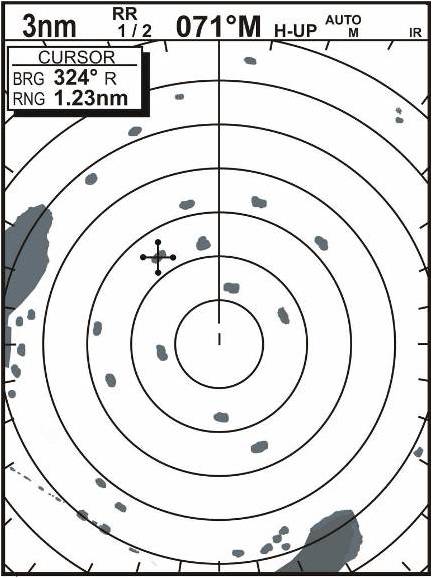
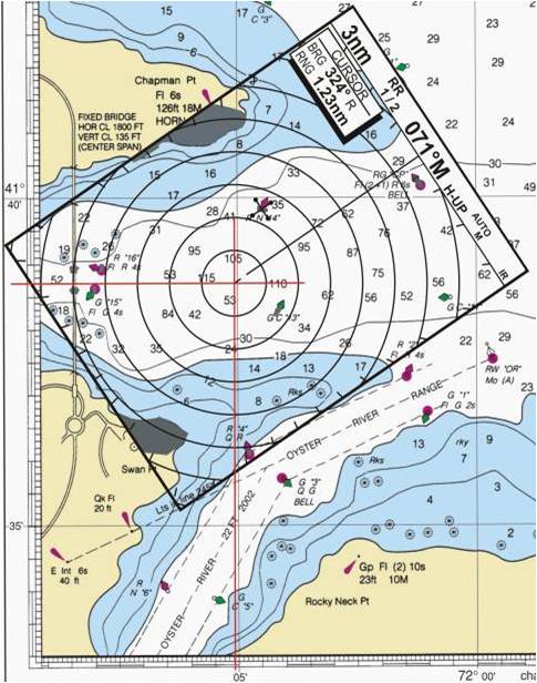
Determine your position, based on Bowdich Bay chart.
1. This is like using clues to solve a mystery. Start with what you know.
- Heading is 071° M, convert to true (056°)
- Cursor is at 324°R, convert to true
 TB = TH + RB(True Bearing = True Heading + Relative Bearing)
TB = 056 + 324 = 380. Subtract 360 to get
TB = 020°
- Land mass to your port is about 2.2 nm at closest point.
- RB to extreme point of land mass is about 309°.
You coiuld use your circular or other protractor (if you have one), or use the course plotter - set bulls-eye at center of radar screen, and align the parellel line that goes through the bulls-eye with the edge of the island.
The "heads up" line crosses the scale on the course plotter at 309°
- Land mass to starboard is about RB 142° and about 2.3 nm.
- You could draw this pattern on tracing paper and slide it along the charts until you see a "fit", like shown below.
- If you're very observant, you might detect the bridge in the lower left hand corner of the radar display.